
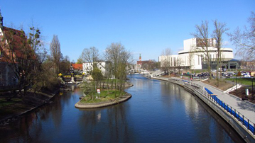
REGIONAL INFORMATION:
Praha / Czech Republic
Area: 495,9 km²
GDP (PPS per inhabitant): 38.400
GDP Index EU 27: 162,3
Tourism, film industry, Manufacturing, Electroengineering, Polygraphy, Financial centre, Business activity
www.praha.eu/jnp/en/visitors/index.html
www.virtual-zoom.cz/praha_mag_mapa/praha.html
Official Website:www.praha-mesto.cz

If you are not yet a member you can register here.
| CEBBIS | Central Europe Branch Based Innovation Support | |
 |
Regional partner(s): |
|
| ACCESS | ACCelerating regional competitivenESS and sector-based excellence through innovation management tools and techniques | |
 |
Regional partner(s): | |
| ClusterCOOP | Enhancing Framework Conditions for an effective Transnational Cluster Cooperation in Central European | |
 |
Regional partner(s): |
|
| CentraLab | Central European Living Lab for Territorial Innovation | |
 |
Regional partner(s): | |
| NANOFORCE | Nanotechnology for Chemical Enterprises – how to link scientific knowledge to the business in the Central Europe space | |
 |
Regional partner(s): | |
| Re-Turn | Regions benefitting from returning migrants | |
 |
Regional partner(s): |
|
| i.e.SMART | SMART Training Network for Innovation and Entrepreneurship in Emerging Sustainable Economic Sectors | |
 |
Regional partner(s): |
|

| ChemLog | Chemical Logistics Cooperation in Central and Eastern Europe | |
 |
Regional partner(s): | |
| SoNorA | SOuth-NORth Axis | |
 |
Regional partner(s): | |
| BICY | BICY – Cities & Regions of Bicycles | |
 |
Regional partner(s): | |
| EMPIRIC | Enhancing Multimodal Platforms, Inland waterways and Railways services Integration in Central Europe | |
 |
Regional partner(s): | |
| SPES | Support Patients through E-services Solutions | |
 |
Regional partner(s): | |
| INWAPO | Upgrading of Inland Waterway and Sea Ports | |
 |
Regional partner(s): |
|
| EDITS | European Digital Traffic Infrastructure Network for Intelligent Transport Systems | |
 |
Regional partner(s): |
|

| 4BIOMASS | Fostering the sustainable usage of renewable energy sources in Central Europe – putting biomass into action | |
 |
Regional partner(s): | |
| ACT CLEAN | Access to Technology and Know-how in Cleaner Production in Central Europe | |
 |
Regional partner(s): |
|
| COACH BioEnergy | Strengthening the energetic use of biomass in Central and Eastern Europe by establishing a standardised transnational consulting net for regions | |
 |
Regional partner(s): | |
| LABEL | Adaptation to flood risk in the LABE-ELbe river basin | |
 |
Regional partner(s): | |
| URBAN-SMS | Urban Soil Management Strategy | |
 |
Regional partner(s): | |
| GOVERNEE | Good Governance in Energy Efficiency | |
 |
Regional partner(s): | |
| CE-FRAME | Central European Flood Risk Assessment and Management in CENTROPE | |
 |
Regional partner(s): | |
| INCA-CE | INCA Central Europe – Integrated nowcasting system for the Central European area | |
 |
Regional partner(s): | |
| EnergyCity | Reducing energy consumption and CO2 emissions in cities across Central Europe | |
 |
Regional partner(s): | |
| UFIREG | Ultrafine Particles – an evidence based contribution to the development of regional and European environmental and health policy | |
 |
Regional partner(s): | |
| UHI | Development and application of mitigation and adaptation strategies and measures for counteracting the global Urban Heat Islands phenomenon | |
 |
Regional partner(s): | |
| ENERGYREGION | Effective development of dispersed renewable energy in combination with conventional energy in Regions | |
 |
Regional partner(s): | |
| CERREC | Central Europe Repair & Re-use Centres and Networks | |
 |
Regional partner(s): | |
| CEP-REC | Introduction of Regional Energy Concepts | |
 |
Regional partner(s): | |
| CEC5 | Demonstration of energy efficiency and utilisation of renewable energy sources through public buildings | |
 |
Regional partner(s): |
|
| CombinES | Combining energy services with subsidy schemes to finance energy efficiency in Central Europe | |
 |
Regional partner(s): | |
| E2BEBIS | Environmental and Economic BEnefits from BIochar clusterS in the Central area | |
 |
Regional partner(s): | |
| PRESOURCE | Promotion of Resource Efficiency in SMEs in Central Europe | |
 |
Regional partner(s): |
|
| CUSTODES | Cultural Sites and Tourism: Development of European Strategies | |
 |
Regional partner(s): | |
| CIRCUSE | Circular flow land use management | |
 |
Regional partner(s): | |
| ReNewTown | New post-socialist city: Competitive and Attractive | |
 |
Regional partner(s): | |
| EPOurban | Enabling Private Owners of Residential Buildings to Integrate them into Urban Restructuring Processes | |
 |
Regional partner(s): | |
| ETNOFOLK | Preservation and Enhancement of Folk Culture Heritage in Central Europe | |
 |
Regional partner(s): | |
| ADAPT2DC | New innovative solutions to adapt governance and management of public infrastructure and services to demographic change in shrinking regions and cities of CE | |
 |
Regional partner(s): |
|
| HELPS | Housing and Home-care for the Elderly and vulnerable people and Local Partnership Strategies in Central | |
 |
Regional partner(s): |
|
| CITY REGIONS | Increasing the competitiveness of city regions through integrated urban-rural development | |
 |
Regional partner(s): |
|
INCA-CE – Hydrology actions in Poland
The main activities carried out within this pilot actionincludes:
– conducting systematic hydrological measurements and observations,
– collection, storage and processing hydrological data,
– providing hydrological products and services to public sector and commercial organizations,
– development of hydrological mathematical models.
The Cracow branch of the IMWM hydrology department covers the area of Małopolskie, Podkarpackie, partly Świętokrzyskie and Śląskie Voivodships. The network of water level stations consists of 203 stations of which 185 are automated. The network of meteorological stations amounts to 269. 241 of them are automatic.
Characteristics of the pilot area
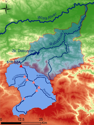
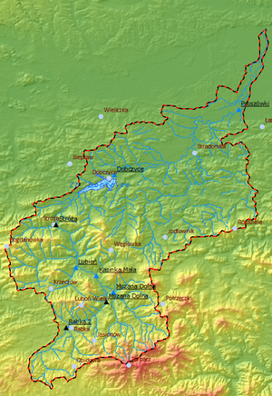
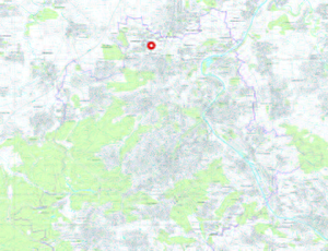
Raba River is the Carpathian tributary of the Vistula River. Location of the Raba River catchment is shown in the Fig. 1. Generally, the river flows in a north – west direction. Its total catchment occupies an area of 1537.1 km² and its length amounts to about 132 km. There is a water reservoir Dobczyce located in the river, above which water level station Stróża is located. Stróża is the closing profile of our studies and it defines the catchment which amounts to 644.09 km2.
15 km downstream from the source area several small mountain tributaries flow into the Raba river, the largest of which is Żeleźnica. Below Rokiciny town river looses the character of a mountain stream, it flows slowly in a riverbed of a width from 5 – 8 meters. In the vicinity of Rabka town Raba River takes two streams flowing from the Gorce Mountains: Poniczanka (catchment area: 32.48 km2) and Słonka (catchment area: 8.83 km2). These streams are draining water from the western part of the Gorce Moutains. They also transport significant amounts of debris, which result in large amounts of gravel below their mouths.
The most significant tributaries above the Dobczyce reservoir are:
– Mszanka River (catchment area 174.13 km2),
– Kasinianka River (catchment area 48.82 km2),
– Lubieńka River (catchment area 48.16 km2),
– Krzczonówka River (catchment area 93.01 km2).
The map below shows the whole catchment of the Raba River with its most significant tributaries and water level stations.
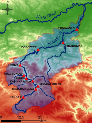
The Raba River begins its course in the flysch area at the height of 780 meters above the sea level near the pass on the boarder of the Gorce Mountains and Beskid Żywiecki Mountains. The western slopes of the Gorce Mountains are drained by the system of concentrated small streams. The upper part of the Raba River catchment is built by flysch sediments. Only in the part of the catchment, between the mouth of the Rabka River and the Mszanka River, shales and sandstones of the Cretaceous are covered by sandstones of the Tertiary and shales.
The upper part of the Raba River catchment is situated in the mountainous climatic region. Source area (about 8 km of the upper Raba River) is under the influence of a temperate cool climate The rest of the catchment remains under the influence of temperate warm climate. The average annual sum of precipitation amounts up to about 900 mm. Average rainfall during summer amounts from 500 – 550 mm.
The pilot area with the main river, its catchment, most significant tributaries and water level stations are shown in the map below.
Users/stakeholders in the pilot region
The main user in the pilot region is the Hydrological Forecasting Office in Krakow (part organizational unit of Institute of Meteorology and Water Management National Institute Research – IMWM NIR). The office disseminates data, forecasts and warnings to governmental, provincial decision-making bodies and other users. The following users in the pilot area are recipients of above mentioned actions:
- Małopolska province civil protection agency / Wojewódzkie Centrum Zarządzania Kryzysowego w Krakowie
- Małopolska province melioration and water devices administration / Małopolski Zarząd Melioracji i Urządzeń Wodnych w Krakowie
- Bochnia county civil protection agency / Powiatowe Centrum Zarządzania Kryzysowego w Bochni
- Sucha Beskidzka county civil protection agency / Powiatowe Centrum Zarządzania Kryzysowego w Suchej Beskidzkiej
- Bochnia community civil protection agency / Powiatowe Centrum Zarządzania Kryzysowego w Bochnia
- Kraków county civil protection agency / Powiatowe Centrum Zarządzania Kryzysowego w Krakowie
- Kraków city civil protection agency / Miejskie Centrum Zarządzania Kryzysowego w Krakowie
- Kłaj community civil protection agency / Gminne Centrum Zarządzania Kryzysowego w Kłaju
Implementation of pilot actions
At present time, IMWM, uses the System of Hydrology (SH) application used as a database, for generating reports and also used for forecasting (it contains the Modelling Platform that includes several hydrological models that create forecast for some reservoirs in the Upper Vistula catchment). On the IMWM website there are all valid hydrological warnings (with the warning level, validity, type of warning etc.), meteorological forecasts (like COSMO/LM7 short-term forecast, GFS long-term forecast or Aladin short-term forecast), current meteorological radar images and satellite images.
IMWM also uses applications like PROMET (used for generating meteorological reports, viewing and generating meteorological warnings, viewing radar and satellite images etc.).
Currently, in the Raba River catchment we want to implement the rainfall-runoff model MIKE 11 NAM. The model is built in DHI Mike 11 software (NAM model). The model is based on the meteorological and hydrological data (from the period: 01.11.2005 – 01.11.2010) concerning the pilot area. The values of potential evapotranspiration are obtained from the EUMETSAT’s SAF on Land Surface Analysis.
The Raba River to the closing profile Stróża consists of 6 subcatchments of total area of 644.09 km2. Area of each subcatchment is shown in the table 1.
Tab. 1. Subcatchments in the pilot area.
River Water level station Catchment Area
Raba Rabka 2 91,84 km2
Raba Mszana Dolna 157,16 km2
Mszanka Mszana Dolna 166,43 km2
Raba Kasinka Mała 353,31 km2
Lubieńka Lubień 47,78 km2
Krzczonówka Krzczonów 89,67 km2
Raba Stróża (final profile) 644,09 km2
The NAM rainfall-runoff model results will be used for inflow forecasting of the Dobczyce reservoir. It is expected that implementing INCA-CE in operational hydrology will improve the quality of the forecasts.
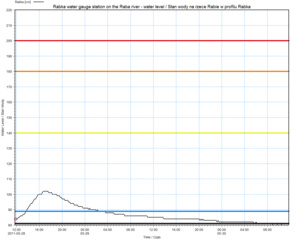
Using the MIKE Flood Watch application, every hour of the day there will be an automated task generating water level graph (with sensor’s thresholds shown – fig. 1) and the Raba catchment current status map (examples shown below – fig. 2) with color-coded water level thresholds transgressions (each water level zone has its color code – there is the lower, medium and high water level zone plus the warning and alarm water level).
All the graphs and maps can be personalized for the Hydrological Forecasting Office in Krakow – there can be either the whole Raba catchment taken into consideration or just a small portion of it (or subcatchment).
For all the meteorological and hydrological stations there will be the INCA precipitation forecast available every hour (the timestep being either 10 minutes or 30 minutes).
In the future a webpage will be made with the mentioned above water level graphs, status maps (with INCA and the hydrodynamic model forecast results, similar to fig .2 but with different color codes) and slide shows with INCA and other forecasts. At the moment there is no model used regularly in operational hydrology. The Hydrological Forecasting Office in Krakow uses synoptic forecasts and forecasts from mathematic models meteorological for large area with updating twice a day. System INCA will provide meteorological forecasts the operational hydrology for small area for 2-6 hours forward with updating every 30 minut. It is important product to improve input data to creating of hydrological forecasts. Depending on the developing hydrological situation in the Raba catchment, there could be several action taken – like automatic e-mails or sms messages being sent to crucial users/stakeholders in the pilot region with information about the warning level, severity and validity.
INCA-CE – Hydrology actions in Czech Republic
Characteristics of the pilot area
The pilot areas are shown on followng figures. The figure 1 depicts the area of the Morava and Odra river basin – the example of the precipitation input data for the hydrological model HYDROG used for discharge forecasts calculation is presented. On figure 2 the selected pilot catchments for the flash floods forecasting systems are shown. The selected catchments were hit by a flash flood in recent years.
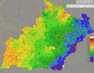
Fig. 1 The example of precipitation input for the hydrological model HYDROG. This model is used for the calculation of the discharge forecast in the Morava and Odra river basin within the Czech Republic.
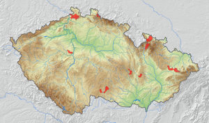
Fig. 2 The map of catchments for which the pilot implementation of the flash flood forecasting system will be done.
Users/stakeholders in the pilot region
Concearning the large-scale floods the discharge forecasts are published on the CHMI web site (hydro.chmi.cz).
Concearning flash flood system the situation is more complicated. Some of the end users (the members of local flood commisions) were already contacted (Dačice, Rožnov pod Radhoštěm). The flash flood prediction is very uncertain, that is why the training of the end users is one of the main parts of the whole flash flood forecasting system.
Implementation of pilot actions
The work of CHMI concearning the implementation of precipitation nowcasting techniques in operational hydrology is concentrated on two topics:
1. Improvement of large-scale floods prediction
CHMI calculates 48 hours discharge predictions for more than one hundred watergauges within the territory of the Czech Republic, forecasts for 89 watergauges are published on the website (hydro.chmi.cz). As standard input the precipitation and temperature forecast of numerical weather prediction model ALADIN is used. Since 2007 for the first three hours of the predicted period the precipitation nowcast COTREC (Novák, 2007) is used for hydrological calculation for whole Morava and Odra river basins. Other nowcasting tools as INCA will be tested on case studies and will be integrated to the existing data processing scheme to be used for hydrological calculations operationally. The example of the potencial benefit of precipitation nowcasting used for the calculation of the large-scale flood forecasts is depicted on figure 3.
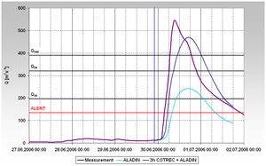
Fig. 3 The example of the benefit of the precipitation nowcasting (COTREC) used in the calculation of the discharge forecast in the Dyje catchment (the simulation of the extreme flood wave from June 2006). The discharge forecast based on COTREC (used for the first three hours of the predicted period) completed by the NWP model ALADIN precipitation forecast was much more accurate than discharge forecast based only on ALADIN precipitation forecast.
2. Creation of the flash flood prediction system.
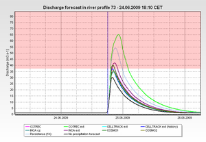
Flash floods caused by heavy convective precipiation which hits small catchments are very dangerous kind of phenomena which are not easy to be predicted. The main problem is in the estimation of the causal precipitation, for which the combination of raingauges data with the radar quantitative precipitation estimates derived from radar measurement is used. The development of the actual precipitation field is then calculated from the extrapolation of the recent radar images. With the use of these techniques some of the flash floods can be predicted several tens of minutes in advance. CHMI will establish the flash flood forecasting system based on the use of several precipitation nowcasting methods (the example of the output – see Fig. 4). The system will be tested on several case studies and within the testing operation on the selected pilot catchments.
INCA-CE – Civil protection in Austria

Introduction
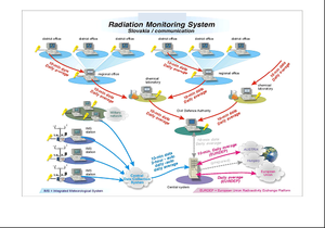
The organisation of civil protection and disaster management in Austria is shown in the following diagram:
At the federal government level, the Ministry of Interior coordinates disaster preparedness and response of the federal government. It provides support to provinces in disaster management and develops, together with all national stakeholders, long term strategies in disaster management. Provinces are responsible for the legal framework and large scale disasters, while district authorities form the main disaster management organisations.
Within the INCA-CE project, partners from all described levels are represented:
- Federal Government: BMI (PP10)
- Provinces: LSZ-B (PP8), NOEL-CP (PP9)
- District authorities: NOEL-CP (PP9)
- Municipality: NOEL-CP (PP9)
Cooperation between the Austrian national weather service ZAMG (LP) and Austrian civil protection partners LSZ-B (PP8), NOEL-CP (PP9) and BMI (PP10) have a long standing tradition. In the following, the current pilot actions are detailed and the planned improvements are summarised.
Characteristics of the pilot area
Lower Austria
In Lower Austria, the civil protection partner of ZAMG (LP) is the provincial government of Lower Austria, section for fire brigade and civil protection, NOEL-CP (PP9). Cooperation between both partners exists since many years. ZAMG provides weather warnings, forecasts and nowcasting information via specific information channels (SMS warnings, internet portals, 24h telephone hotline) to NOEL-CP. Responsibilities of NOEL-CP within Lower Austria include:
- Legal affairs of the Fire Service and disaster management.
- Organisation of the Disaster Management of Lower Austria.
- Administration and organisation of the governmental incident command.
- Administration of the Fire training Center of Lower Austria.
- Administration of the Civil defence.
- Civil protection in the field of radioactive threat.
- Administration and organisation of the warning alarm centre.
The area of intervention of NOEL-CP (shown in figure below) counts 1.5 Million inhabitants, an area of 19,177km2 and is constituted of forest by 39%. Major threats that have to be handled by NOEL-CP are: storm, thunderstorm, flooding, snow in combination with wind, cold temperatures and ice hazards.
Burgenland
Similar to Lower Austria, there is also a close cooperation between ZAMG and the safety centre of Burgenland LSZ (PP8). Duties of LSZ comprise:
- Operating the integrated emergency control centre “LSZ Burgenland“.
- Emergency services,
- fire-brigade,
- Civilian, national warning centre.
- Support of the countrywide warning and alarm system.
- Operating and supporting the bundle radio network.
- Operating and supporting the storm alarm system.
- Supporting the disaster management of Burgenland.
- Supporting the civil defence.
- Supporting the civil protection in the field of radioactive threat.
Users/stakeholders in the pilot region
Besides NOEL-CP (PP9) and LSZ-B (PP8) the following stakeholders in the respective region will be informed, and if possible, integrated in the pilot actions:
- Lower Austrian/Burgenland civil protection agency
- Lower Austrian/Burgenland Fire Association
- Austrian Red Cross
- Lower Austrian/Burgenland Samaritans
- Lower Austrian mountain rescue and water rescue
- Lower Austrian/Burgenland police command
- Lower Austrian/Burgenland military command
- Crisis intervention teams
1.
INCA-CE – Civil protection in Slovakia
Introduction
Civil protection in Slovak Republic is organized as a system, which provides the constitutional right of citizens, consisting from protection of life, health and property again the results of disasters. Legislation set up tasks and scope of government and its bodies, self government, and also rights and obligations for ensuring tasks of civil protection. The achievement of governmental administration in the field of civil protection is directed by Ministry of Interior of the Slovak republic. Besides other competencies, it manages and organizes on national level tasks of civil protection informational system. District office, District office in the seat of county and the municipality has similar scope on regional level – on its territory.
On the base of agreement between Ministry of Interior of the Slovak republic (“Ministry”) and the Slovak Hydrometeorological Institute (“Institute”) on cooperation during providing and using of information, are realised measures from the field of (some) tasks of the informational system. This agreement set up preconditions for building and organization of early warning and informing after appear of disasters on the territory of Slovak republic, or out of it.
Both actors of this agreement cooperate with private companies on the basis of software and hardware development, equipment and complex solution of systems for environment protection and monitoring systems.
Extension of products and information provided on agreement base
- Data from monitoring – Slovak Republic and neighbour countries (on-line intheformation from z meteorological stations with database of measured parameters, attitude wind and temperature),
- Degree of stability – vertical stability of atmosphere: inversion, isotherm, convection
- Weather forecasts (text forecast for particular 7 days, text forecast for month, forecast of medial daily rainfall for particular river-basins),
- Alert before occurrence or expected occurrence of dangerous atmospheric events: (intensive rainfalls, heavy wind, intensive snowfall, snow drifts and snow-banks, glare ice, extremely low temperature, heat, fog),
- Hydrological information from monitoring, water level from gagin stations, in which is dedicated level of flood activity, alerts – warnings, achievement of 1. Level/grade of flood activity.
- Radioactivity of the air background (data from monitoring, on-line information from 23 monitoring stations in format of 10 minutes average of the gamma dose rate in air) .
Partners commit oneself to provide (via their manage communication points – in following text only “Communication Point”) information and alert messages for the use of coordination centres of integrated rescue system, which are established on district offices in the seat of county.
Coordination centre as a key element on regional level is the frame of project a subordinated Communication Point (in the following text “Subordinated Point”) between tactical, operational and strategic level of management on its territory. Via the points runs the transfer of data flow, which is recorded in the space of informational-communicational technology.
This principle saves:
- actuality and complexity of information flow to all necessary places,
integrated informing/notice and warning of population.
Characteristics of pilot areas
In accordance with project´s objectives and with tasks resulting from realisation of conceptual governmental documents focusing on integration and finalization of the set-up early warning system and informing/notice, in medium term and short term future, activities focused on building of functional communication system between Institute and Ministry, with purpose for receiving of early warnings/alerts, and for immediately distribution to the regional level.
The created integrated system will serve for support of decision making – of bodies which takes part on rescue works, or manages the rescue works during disasters. It is automatized system with data communication. Informational-communicational technology of support system for information managing and processing (which will be send by e-mail) is proposed as an integrating scene (envinroment).
- system of collection, distribution and presentation of meteorological and hydrological alerts and climatology data,
- system of radiation monitoring data collection and exchange.
Emphasis will be focused on integration of hydrological alerts into unitized system.
Definition of content and of proposed extension of systems
System of collection, distribution and presentation of meteorological and hydrological alerts and climatology data
Objective of those systems is to acquire meteorological and climatology data about the weather status, about status and evolution of climatology system for:
- providing meteorological and hydrological information, forecasts and alerts, climatology services and information for other fields,
- providing data for detection and monitoring of climate drift and changing of climate, for the assessment and reduction of impact of climate changes,
- proposing qualified measures to reduce eventually negative consequences of climate changes, data providing for exploration and knowing of process in climate system, for climatology forecasts and modelling.
The progress and asset consist from improvement of warning and information service in the system of civil protection in Slovak republic, by faster and more qualitative data providing to the users.
Users and involved parties in the pilot area
Excepting the civil protection system in a given region, following forces will be informed, and if possible integrated into pilot actions:
- Fire and Rescue Corp of Slovak Republic,
- Police Force of Slovak Republic
- Mountain Rescue Service,
- Slovak Red Cross,
- Territorial Self-Government
- bodies of self government,
- NGO performing tasks of civil protection during disasters (example: Association of Slovak Samaritans).
The result of acquired data for users will be more qualitative planning (and with required lead time) of activities necessary to secure the protection population´s life, health and property.
Is concerned areas (goals)
a) Assessment, appraisal of situation
- season of the year – sport activities of population,
- the period of day (day / night),
- traffic situation (rush hour, weekend, holiday season),
- kind of disaster,
- critical infrastructure (drink water supply, electricity supply and others),
- interest regions for specific kind of disaster,
- combination of present situation with weather and weather evolution.
b) Planning (decision making)
- warning of population, informing of decision makers and of forces,
- monitoring of the situation,
- planning of forces and equipment which are necessary during particular kinds of disasters,
- evacuation or “covering” of population,
- giving of orders for execution of rescue works.
This is a general understandable system, which provides current alerts before expected dangerous meteorological events (using symbols and coloured maps). The level of warning is visualised by unific system with back up with clear connection between meteorological (hydrological) events and their possible results, together with recommended behaviour to minimize accrued damages.
Event: wind
Level / degree: 2
Time line of the event: January 23 2011 from 10:50 a.m. to 17:00 p.m.
Colours: green – without dangerous events; yellow – 1. level; orange – 2. level; red – 3. level.
Proposed integrated system implements some established systems of evidence and distribution of alerts, which are delivered by the Institute. According the relevance and local situation alerts will be provided via Communication Points and Subordinated Points to the users mentioned above. System runs via central server, which makes: collection of alerts from monitoring networks in Slovak republic, visualization and distribution to other recipients.
Central server is equipped with central database of received messages on the base of Oracle server. System is composed by those main modules:
- module for collection and distribution of alerts to Communication Points and Subordinated Points – coordination centres of Integrated Rescue System,
- module for alert visualization
- Client module (recipients of alerts)
System runs under the operational system MS – Windows Server.
To his interface is applied access trough web interface, therefore is possible to work with the system also from outlying computers with other operational systems. The only condition is installed web browser. Transfer of synoptic data runs trough ftp protocol, when central server provides service of FTP server. In the next step is done:
- decoding of meteorological data,
- import to the database,
- data consistence verification (control of quality).
For data imaging the system provides several applications in form of maps, charts and graphs. In one graph different values from different stations are displayed, for example “10 minutes data” from automatic weather stations for the purpose of modelling, radiation date from Institute network, data of class stability and others.
System of data radiation monitoring collection and exchange
System of data radiation monitoring collection and exchange is existing system. It is operated for a long time trough hierarchical network of 23 monitoring stations in the system of civil protection. Station in case of increase of level dose rate over emergency limit sends warning acoustic and visual alarms. Superior stations are informed about this alarms via e-mail, which are not confirmed by recipients.
The whole network cooperates with:
- the radiation monitoring of The Slovak Hydrometeorological Institute (having more
- than 25 stations),
- Hungarian and Austrian monitoring systems, and ISPRA,
- and with the EURDEP system (EU Radioactivity Platform),
- ICRP – International Commission on Radiological Protection.
In the frame of proposed project existing system will be enlarged by:
- web interface for interactive presentation of data through web,
- reporting generator
- notification system informing trough SMS messages and mail about increased level of radiation
insertion of measuring stations into virtual private net.
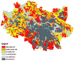
URBAN-SMS – Urban soil management in Prague (CZ)
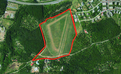
“Meadow” near the botanical garden (9.5 ha)
The demand for new residential areas in the City of Prague generates huge pressure on green areas and the few remaining natural soils within the urban area. There is an urgent need to develop concepts and tools to decrease the quantitative consumption rate of soils and to integrate the soil quality parameters into the sustainable soil use methodology. The pilot area “Meadow” exemplifies the difficulty between the development interests of the private owner and the need to safeguard high quality green areas.
The pilot area in the green belt area north of the Vltava River
Situation on the test area
The test area is located in the northern city district of Troja which is considered a prestigious and highly desirable area for family housing, and is hence under constant pressure from developers. It is expected that the privately owned “Meadow” which is currently under agricultural use will shortly be sold to a construction company to establish new dwellings. For that purpose the owner will have to go through the land use change procedure according to the Czech Act. In contrast, the area is characterised by its high ecological function and its importance for the urban green concept.
URBAN SMS activities
Due to the fact that there are no practicable tools and concepts for handling soil quality in the urban planning process the soil functions of the pilot area needed to be evaluated and visualized. Improving the consideration of high quality soils as well as awareness raising at a local level was the focus of the pilot study to limit, and where this was not possible, to compensate soil losses. “Soil Manager Suite” together with “Guidance for Soil in SEA/EIA”, “Brownfield Redevelopment as an Alternative to Greenfield Consumption in Urban Development in Central Europe” and “Awareness Raising Package” were used in consultation with local NGOs and with municipal representatives to achieve better implementation of soil protection in the decision making
process. The soil quality of the “Meadow” site from both production and ecological aspects was evaluated and compared with a nearby Brownfield area close to the Vltava River to find a potentially less valuable area for
construction.
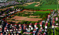
Pilot area “Meadow” in the northern city district of Troja in the City of Prague
Results and experiences
Application of the tool demonstrated the unique properties of the pilot site, especially its ecological value. The comparison with the Brownfield site near the Vltava River shows that the “Meadow” is characterised by a much
higher need for protection. Due to the lower soil quality and moderate contamination at the Brownfield site the future urban development should be concentrated there instead of at the pilot area “Meadow”. However, if a change in the land use will be realised, possible measures to limit soil sealing and to compensate the soil consumption are already specified.
URBAN-SMS – Urban soil management in region of Salzburg (AT)
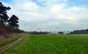
Salzburg City and hinterland (261 km2)
The area is the main industrial and commercial centre of the Land of Salzburg and a transport intersection. A regional development program has been established in order to secure a commonly agreed spatial development. Considering soil protection in these processes is necessary because already much cropland and grassland with soils of high quality have been converted into a residential area in this region.
Situation of the test area
The regional association of City of Salzburg and ten surrounding municipalities are responsible for the test area in terms of regional spatial planning. In this region high rates of land consumption on medium to high quality arable soils due to urban and suburban development have been observed during recent decades. In future, land use changes due to (sub)urban development can be expected to continue as in the past. The number of inhabitants is about 200,000 with an increase of 14% between 1981 and 2010. Several nature protected areas and natural spots are located in this area and the nature protection regulations are strong against
land use conversion.
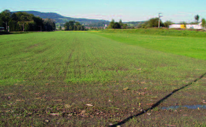
Photo of northern part of test area in the Land of Salzburg
URBAN SMS activities
During the project the selected software tools for soil evaluation were applied with some limitation of available data regarding soil parameters. Soil quality was assessed in relation to past and future regional and local land
planning as well as the Strategic Environmental Assessment. Special focus was laid on already built on land or areas with land use just changed (dedicated for building development by land use plans) assessing their relation with the total agricultural land and the soil quality.
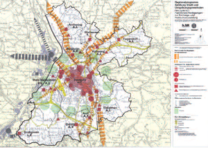
Functional determination of development of settlement areas and open space (part of regional development program)
Results and experiences
Now a comprehensive knowledge base about soil quality and its suitability for different land use exists. The results of the case study helped to steer regional land planning towards the most suitable areas for certain purposes. Minimization of soil consumption, in particular of valuable agricultural land, is possible in future development.
URBAN-SMS – Urban soil management in Stuttgart (DE)
“Langenaecker-Wiesert” (8.8 ha)
In Stuttgart the main problem is the increasing pressure on high quality soils outside the settlement area. The chosen pilot area is an example of this negative development. According to the local building plan a residential area with 260 units is planned on arable land with soils of high quality.
The pilot site on the northern border of the densely populated city of Stuttgart.
Situation of the test area
Current use of the area is arable land and garden plots on high and very high quality soils. It is already bordered by settlement areas on three edges. It is part of a 46 ha contiguous area with soils of also high and very high quality. The building plan is in the process of being developed at the moment.
URBAN SMS activities
The most important strategy in this pilot case is to raise awareness of the huge loss of soils with high quality and to involve stakeholders/decision makers at an early stage of planning. The URBAN SMS Awareness raising package is therefore a helpful tool, e.g. the report “Environmental impact of urban soil consumption” (ahu, 2011). For calculation of the loss of soil quality the “Loss of Soil Resource” (LSR)-tool was applied on the basis of the soil quality map and the soil protection concept (BOKS) of Stuttgart. The technical implementation to calculate the current soil quality and also the prognosis of the loss of soil was carried out with the adapted LSR-module for ArcGIS “Technical Concept Soil indicator Stuttgart – Application”. The result is a certain number of “soil index points”, which are calculated by multiplying the score for soil quality (0 to 5) with the area size [ha]. This corresponds with the compensation demand.
Results and experiences
The test area “Langenaecker-Wiesert” is an example of where the overall goals of soil protection defined in URBAN SMS are not achieved. However, with URBAN SMS software modules it is possible to make the loss measurable and visible. After implementation of the planned building activities there remains a calculated deficit of 22.4 soil index points compared to the current status. This is more than the whole loss of soil quality in Stuttgart between 2007 and 2011! Only measures of mitigation are possible in this case, for complete compensation these measures are insufficient. There are not enough areas available to realise adequate measures. This problem is described in detail in “Compensation Measures for Encroachments on Soil – Stuttgart Assessment”. But with the mentioned strategies and tools we are able to provide the decision maker with the information about the consequences of the planning activities so that they are aware of the negative impacts and avoid future losses.
URBAN-SMS – Urban soil management in Wrocław (PL)

Wrocław LAU-2 region (293 km2)
The city of Wrocław was taken as a test area covering roughly 293 km2. Agricultural lands still cover 43% of the total area whereas the area of sealed surfaces has reached 39%. Forests cover 7% and water bodies 3.5% of the total area.
Situation of the test area
There are instruments in national legislation aimed at protecting high quality agricultural soils (The act on agricultural and forest land protection). The protection mechanism is based on fee payment of the developer and obligatory permission by the ministry to transform the best soils into non-agricultural uses. Soils within urban administrative borders are, however, currently excluded from this regulation; this fact creates additional risks for loss of valuable soils in Wrocław. Consequently, there is significant pressure on high quality soils located especially in the southern part of the city.
Urban sprawl in Wrocław between 1991 and 2006 on soil quality map
URBAN SMS activities
The project GIS web system has been applied and tested in the Wrocław pilot area, whereas SEA/EIA guidance and awareness raising materials where delivered to stakeholders. Extensive spatial analyses were performed to assess the land use change trends within the city, and losses of soil resources and various modelling approaches were applied to predict future consequences of current soil management. The results of these analyses were provided to the stakeholders in order to raise their awareness of the role of soil in urban zones as well as current trends in soil consumption and impacts of limited soil protection on environmental and socio-economic issues. The meetings were organized with a representative group of stakeholders as an example of effective stakeholder participation in the impact assessment process and discussion on soil management issues.
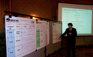
Stakeholder meeting aimed at raising awareness and gathering information on key sustainability issues in the city
Results and experiences
The knowledge provided during meetings helped to raise awareness and reach a common understanding of soil protection goals and conflicts between urbanization and environment quality. The stakeholders expressed a strong need for further development of spatial digital information on environmental issues useful in better management of soil resources. There was a common agreement on the need for revision of soil protection regulations and more successful inclusion of soil issues in urban planning.
COBRAMAN – Green stop-over at the Brda River, City of Bydgoszcz (PL)

Pilot project scope
The aim of the pilot investment was to conduct a transparent process of regeneration coordinated by a brownfield manager. It was planned to clean up the soil and develop the site for the recreational use.
About the site
Bydgoszcz City is the 8th most populated city in Poland that covers the area of 175,98 km². The city is located in northern Poland on the Brda River and Bydgoszcz Canal which define the face of the city. Thanks to the convenient location, the city has become an economic, cultural and water sports hub. Admittedly, the industry spins the economy but it also leaves traces. In the COBRAMAN project the City of Bydgoszcz put the focus on contamination of soil that poses a deterrent in the process of brownfield regeneration.
The area selected to be developed within the COBRAMAN project is owned by the City of Bydgoszcz and it was an unused brownfield at the time of selection. The site covers the area of 1 130 sq metres and yet, as small as it may seem, it is vividly noticeable to the passersby who stumble upon a scary-looking wall remnants and ruins in the very heart of the city along the picturesque riverbank. To make matters worse, it also turns out that the soil quality remains an issue due to the 150-year-long industrial use associated with the processes of gas treatment and production of tar board. The investigations revealed the existence of PAHs, BTEXs, phenols and oils.
Activities during the project
The works on the pilot site comprised ground and groundwater investigations, demolition of the previous infrastructure remains and the remediation works. The soil was cleaned up through the process of excavation of contaminated soil and bioremediation. On the newly purified ground, a leisure area was developed for citizens who can find now a breathing space by the Brda River in the busy hub of the city.
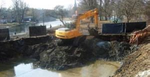
What have we learned?
The unquestionable advantage of the project for the local community is the removal of the ground contamination and hence the improvement of local environment. For the institutions, the integrated brownfield management concept will result in an effective approach towards post-industrial areas in the city. What is not a brownfield today, might become a brownfield tomorrow.
Before the project:
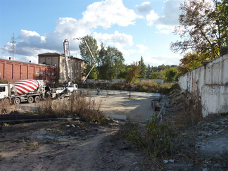
After the project:
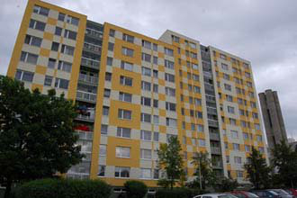
ReNewTown – SME support in Prague 11 (CZ)

Background
Prague 11 (jizni Mesto) is one of the metropolitan districts of the Capital City of Prague with the highest density of population (currently the density is 8 151 inhabitants/ km2). It is also one of the largest areas with blocks of flats (panel-housing) in the Central Europe which were built in 70’s and 80’s in the socialist era as a place to live for new workers and builders. Many negative effects, e.g. lack of parking places, necessary regeneration of the prefabs or adjustment of semi-public areas are concentrated here.
Objective
The main objective of the ReNewTown pilot action is to create a “Centre for Small and Medium Enterprises” showing possibilities how the public building with socialist burden may be used in a modern and useful way fitting the needs of the local district.
Results
The establisment of SME support Centre in such metropolitan district shows ways on how to use the buildings with the socialist burden in attractive and useful way to the whole district, attracting local entrepreneurs and stakeholders. The Centre helps existing & new entrepreneurs by providing consultations, organizing various events for entrepreneurs, promoting their work and registerring their business into the Business Catalogue. The entrepreneurs can also benefit from new business networks and contact to local stakeholders.
CERREC – Creative community re-use centre in Prague

Zdrojovna is not just any old junk shop; apart from discarded things we provide our customers with space, tools, paints and the advice of experienced teachers,
who help clients repair and redecorate old things themselves and breathe a new spirit in them.
This project contributes to the prevention of waste creation and leads people to the ideas of sustainable development and 3R principles. Zdrojovna also focuses on the integration of marginalized people, since the project gives them a chance
to feel useful and accepted again. We actively cooperate with other Prague initiatives and companies that deal with recycling, sharing and public space activities.