
REGIONAL INFORMATION:
Kozep-Dunantul / Hungary
Area: 11.117 km²
GDP (PPS per inhabitant): 13.600
GDP Index EU 27: 57,6
Mechatronics and Automotive industry, Electronics, ICT sector, Environment industry, Logistic businesses, Tourism

Komárom-Esztergom megye

Fejér megye

Veszprém megye
If you are not yet a member you can register here.
| CEBBIS | Central Europe Branch Based Innovation Support | |
 |
Regional partner(s): |
|
| AutoNet | Transnational Network of Leading Automotive Regions in CE | |
 |
Regional partner(s): |
|
| CLUSTERS-CORD | Clusters & Cooperation for Regional Development in Central Europe | |
 |
Regional partner(s): |
|
| IDEA | Innovative Development of European Areas by Fostering Transnational Knowledge Development | |
 |
Regional partner(s): | |
| Re-Turn | Regions benefitting from returning migrants | |
 |
Regional partner(s): | |
| CluStrat | Boosting innovation through new cluster concepts in support of emerging issues and cross-sectoral themes | |
 |
Regional partner(s): |
|
| EULAKES | European Lakes Under Environmental Stressors (Supporting lake governance to mitigate the impact of climate change) | |
 |
Regional partner(s): |
|
| HABIT-CHANGE | Adaptive management of climate-induced changes of habitat diversity in protected areas | |
 |
Regional partner(s): | |
| TAB | Take a Breath! – Adaptation Actions to reduce adverse health impacts of air pollution | |
 |
Regional partner(s): |
|
| CE-Ageing Platform | Central European Knowledge Platform for an Ageing Society | |
 |
Regional partner(s): | |
| EURUFU | European Rural Futures – New opportunities to secure the provision of public sevices in rural cities and municipalities | |
 |
Regional partner(s): |
|
| CENTRAL MARKETS | Revitalising and promoting traditional markets in central Europe | |
 |
Regional partner(s): |
|
| Forte Cultura | Capitalising of fortified cultural heritage for sustainable development and competitiveness of cities and regions | |
| Regional partner(s): |
|
|
INCA-CE – Civil protection in Hungary

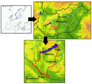
Definition and characteristics of the pilot region in Hungary: Somogy County and the Lake Balaton
The Hungarian Meteorological Service (HMS) has a close cooperation with the Disaster Management Directorate of Somogy County (DMDSC), which had been established many years ago. HMS has wide experiences in forecasting severe weather and in nowcasting. This is above all the case for the Lake Balaton, where special forecasts and warnings are issued by the Storm Warning Observatory in Siófok (Somogy County). The observatory has good contacts with users not only at Lake Balaton but also in the region of Somogy, which is situated south of the lake.
The region of Somogy is partially flat, partially characterized by small heights (below 300m ASL) and valleys. Somogy is an agricultural region (there are wineyards at the Lake Balaton). However, one of the most important financial sources is the tourism at Lake Balaton, which is visited by hundred thousands of tourists every year. A large number of events, festivals (e.g. Balaton Sound), sport competitions and mass sport events (so called Blue Riband yacht competition, swimming world championships, swimming across Balaton, etc.). The capital of the Somogy County is Kaposvár (approximately 70 000 inhabitants). There are several, rather small towns and villages in the county (345 000 inhabitants together). The largest river of the county is Drava, which creates the southern border with Croatia. Most of the rivers belong to the Drava or Danube basin. There is an important channel Sio, which links the Lake Balaton with Danube and it is used for the regulation of the water amount in the lake. The climate of the area belongs to the Maritime Temperate (Cfb) class of the Köppen climate classification (more or less uniform distribution of precipitation, monthly temperature average of the warmest month below 22 °C ). However several extremes appeared during the past years as very dry and hot summers (2003, 2007) and large amount of precipitation (2010). Severe weather events are usually related to mesoscale convective systems and convective lines propagating from the west-northwest (from the Alpine region) or from the southwest (so called Slovenian squall-lines). Almost every year, these events cause wind gusts exceeding 100 km/h, which are very dangerous for human activities, above all at the Lake Balaton.
Users of INCA-CE in the pilot area, tasks, responsibilities
Several stakeholders were informed about the INCA-CE project in the pilot area. They are supposed to be the main users of the INCA-CE analysis and forecasts, as well as the DMDSC situated in Kaposvár and the PP5 external expert (Balaton Integrációs Köszhasznú Nonprofit Kft.). The list of the users (by january, 2011) is as follows:
Balatoni Hajózási Zrt. (BAHART, shipping company)
Balatoni Vízirendészeti Rendőrkapitányság (police at Lake Balaton)
Vízimentők Balatoni Szakszolgálata Egyesület (water rescue team at Lake Balaton)
Aranyhíd Balaton-átúszó Sportklub (sportclub organizing the swimming across Balaton event)
Közép-dunántúli Környezetvédelmi és Vízügyi Igazgatóság Balatoni Vízügyi Kirendeltsége (hydrological service for central transdanubian region and for the Lake Balaton)
Rádiós Segélyhívó és Infokommunikációs Országos Egyesület (National Association of Radio Distress-Signalling and Infocommunications)
Magyar Vitorlás Szövetség (Hungarian sailing club)
More detailed information (including addresses and contact persons) is available in the “INCA-CE potential users list” document on the INCA-CE website.
The WP5 activities in Hungary will be related to following actions:
5.1.1. Pilot coordination roadmap
5.1.2 Feedback loops
5.1.3 Evaluation
5.3.1 Pilot implementation: Civil Protection
5.3.2 Civil protection feedback
5.3.3 Evaluation
It comes from the list of users and cited actions that most of the tasks of HMS will be related to the area of civil protection. The most important are the forecasts of strong wind and gales, especially at the Lake Balaton. Thus, the implementation of the INCA system will start with the wind module, which will be followed later by temperature and precipitation module. The INCA forecasts should be tested on case studies, mostly those, which are planned also for the WP3 workpackage but these should be evaluated in more details for the pilot region from both meteorological and users point of view. The visualisation form of the INCA forecasts should be discussed before running the system operationally, as well as the dissemination method.
The main communication tool between the INCA project and the stakeholders/general public will be the webportal (workpackage 2). This should provide a common basis for the INCA implementation for the countries involved in the project. However, other communication links could work (or could be tested) at regional basis for special products, which are required only by users in the pilot area. Such products could be placed on the webpages of HMS or could be available by ftp from HMS computer server. Feedback from users should be probably achieved by structured questionnaires or by personal communication (e-mail, phone, meetings).
There should be at least two persons from HMS (Kálmán Csirmaz and André Simon), who would be in contact with stakeholders and other project partners involved in the WP5. Contributions to the package (data, programs, documents etc.) will be provided also by other members of the staff involved in the project. Results of the WP5 package will be discussed with responsible persons (mentioned in the INCA-CE work plan) for each of the action listed above.
Inputs, outputs, links to other WPs
The most important thing for the WP5 implementation in Hungary is to ensure the INCA forecasts for the users. This is in close relation with outputs of WP4 (mainly with development of wind gust forecasts in WP 4.4). Case studies are planned also for WP3, for the development of the transnational strategy. Following major case studies will be provided:
20 August 2006 windstorm, its forecast and impact in the pilot area
25 June 2008 thunderstorms (severe weather also in Slovakia, Austria and Czech Republic)
18 July 2009 line of thunderstorms (which influenced also the weather over Slovakia)
15-18 May 2010 synoptic scale windstorm
The results of the case studies might give feedback for improvement of the WP3, WP4 developments. Comparing to WP3, the case studies of WP5 will be analysed more from regional point of view and will focus rather on stakeholders than on civil protection authorities. Besides case studies, some evaluation of the results in the pilot area should be provided on regular basis, which could give at least a simple statistics. Existing verification tools developed for other applications (MEANDER system, WRF) could be used. The forecast results will be compared against analysis (2D evaluation) or reports of single meteorological station. It should be evaluated, whether the INCA improves the very short range forecasts of the WRF model, which will give the input to the system. This part will be very similar to the WP6 task, but it should concentrate on the pilot region and parameters required by stakeholders and users in this area. The results of the evaluation should be discussed with the users and with the Civil Protection (DMDSC), above all in cases with severe weather. Thus, it will have rather a subjective character (the users point of view should dominate) and the results should be related to number of different weather situations or days with some specific weather-dependent activity (windstorms, important events held in the pilot area, etc.). The outputs of the 5.1 and 5.3 actions should be documents, which will summarize the experiences gained in the pilot area from several points of view (meteorologists-developers, forecasters, stakeholders, Civil Protection members). These should be provided to the responsible persons organizing the WP5 work and discussed with other project partners. The meetings of the WP5 representatives of the project partners should help to coordinate the tasks, determine common problems and find solutions. Common forms (the same structure of questionnaires, same methods, criteria of evaluation, etc.) should help to summarize the WP5 results in general.
Feedback
The feedback from stakeholders could be provided by structured questionnaires. The cooperation with the users might answer the following questions:
Do the forecasted parameters and their visualisation reflect the needs, requirements, technical possibilities of the users in the pilot area ?
How does the system work in severe weather situations (access, speed of the information transfer, update frequency).
Does it bring new information to the user ?
Does it bring any financial benefit (direct, indirect) ?
Are the products reliable, if not, specify why.
Does it reflect the specific characteristics of the area, where it is used (local topography, Lake specific weather patterns) ?
Which developments, improvements would be desired in the future ?
Some of the questions should allow more quantitative assessment. The accuracy and reliability of the system could be evaluated by marks from 1 to 5 (useless, bad, nothing special, useful, very good). The questionnaire might be translated to Hungarian language.
Other feedback (regular, scientific) might be documented by data, graphs, images and specific comments giving the background information (e.g. setup used for the system). Case studies should be documented separately – a common form could be defined (e.g. how much time in advance was the windstorm forecasted, accuracy of the predicted peak wind gust vs. observed gust) and common evaluation criteria (the same criteria could be used as for the verification of wind gusts forecasts of the Storm warning observatory of HMS). The case studies might be evaluated with close cooperation of the DMDSC staff.